
LaPlace ZIP Coverage Crosswalk
The State Library's Louisiana Directory of Cities, Towns and Villages supplies the clearest official place-to-postal crosswalk found for LaPlace and nearby St. John Parish communities. It identifies postal places, not precise delivery polygons. The table includes every pairing documented in that source and the USPS destination-label material reviewed. An exact street or unit still belongs in the live USPS lookup.
| ZIP Code | Areas Covered | Post Office | Notes |
|---|---|---|---|
| 70049 | Edgard; Wallace uses Edgard | Edgard | Parish-seat and westbank routing |
| 70051 | Garyville; Mount Airy uses Garyville | Garyville | Separate community and postal label |
| 70068 | LaPlace; Montz in St. Charles uses LaPlace | LaPlace | Cross-parish postal mismatch |
| 70069 | LaPlace destination-label context | LaPlace | Exact delivery role not established in static sources |
| 70084 | Reserve; Lions uses Reserve | Reserve | Separate community and postal label |
The LaPlace ZIP code directory must preserve uncertainty around 70069. Research confirmed that the label appears in USPS destination material, but did not establish whether every use is street delivery, a post-office function, or another service-area role. Do not turn that gap into a claim. The same caution applies to historic labels such as Lions and Mount Airy. They help interpret old directories and envelopes, while USPS should settle current mailing form.
USPS Fields for LaPlace ZIPs
The USPS ZIP Code Lookup has three useful modes. By Address takes an optional company, required street address, optional unit, required city and state, and optional ZIP. By City and State returns postal matches from those two required fields. Cities by ZIP reverses the question and accepts a ZIP. Each mode solves address format, not identity.
| USPS mode | Captured fields | Best use |
|---|---|---|
| By Address | Company, street, unit, city, state, optional ZIP | Standardize one complete address. |
| By City and State | City and state | Find ZIP labels for a place. |
| Cities by ZIP | ZIP | Check accepted postal city names. |
When several matches appear, add the street and unit. Preserve the source version beside the normalized form. A deed may say Airline Highway while a portal shortens the type; an old directory may use a community name that USPS no longer favors. Both strings matter when tracing a dated record.
LaPlace ZIP Crosses a Parish
The most important local quirk is Montz. The State Library table places Montz in St. Charles Parish while giving it the LaPlace postal label and 70068. Therefore, “LaPlace, LA 70068” on an envelope or database row cannot settle which parish assessor, clerk, court, or registrar holds the record. This is the Interest Layer's strongest local myth check: postal city and civic jurisdiction are different facts.
Resolve the parish with the parcel and GIS before following a name. St. John SmartCAMA and the parish map cover St. John property, while a Montz parcel may belong in St. Charles systems. Court and deed records follow jurisdiction, not the familiar mailing label. This one check prevents a LaPlace ZIP code search from joining two unrelated people across a parish line.
Insider tip. Use a parcel or map number to bridge a postal address to the right deed index.
Search LaPlace Residents by ZIP
A ZIP is most useful as a validation field. The Louisiana voter individual form requires it alongside a first name, last name, and birth month and year. The address form requires ZIP, street, and city, with an optional apartment or lot. Neither form returns a ZIP-wide household list. Research did not confirm a whole-ZIP filter in SmartCAMA, the tax site, or the parish GIS.
- Standardize the full street and unit with USPS. Keep both the original and accepted postal strings.
- Confirm the parish through the assessor or GIS. Do not assume 70068 always means St. John.
- Use the correct five-digit ZIP on the voter person or address form. Treat a match as election data, not occupancy proof.
- Move from the ZIP to a specific street or parcel. The LaPlace By Street page owns that address-level workflow.
Louisiana also sells public voter lists by defined criteria through an account-based order portal. The observed public shell did not expose the live criteria or a current fee, so do not promise that a ZIP-wide purchase is available without checking the official charge and format sheets. For ordinary civic questions, the free person, address, parish, and graphical routes are the sound starting points.
LaPlace ZIP Voter Forms
The individual voter form accepts four required facts: first name, last name, five-digit ZIP, and birth month and year in MM/YYYY format. Hidden update controls and submit complete the captured schema. The address route uses ZIP, address, an optional unit or lot, and a dynamic city selection. It can answer a polling-place or representation question and help confirm that an address falls in a parish precinct.
The Louisiana voter name and ZIP form appears below.
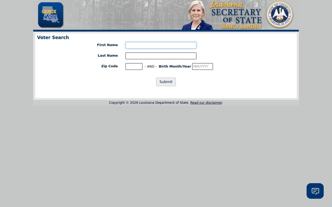
The required ZIP narrows one named voter query. It does not open a list of all residents within that postal area.
The voter address and ZIP form uses a different set of fields.
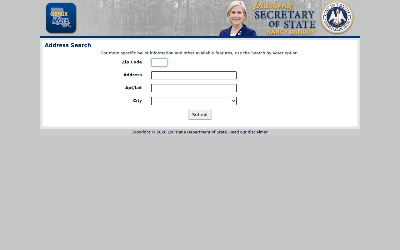
This second view supports civic routing for one address and keeps the ZIP tied to a full street and city selection.
Normalize LaPlace ZIP Records
Keep an address as data fields rather than one loose line. Save the original string, street number, direction, street name and type, unit or lot, city label, parish, ZIP, ZIP+4, and parcel or assessment number. Mark whether the source displays a situs address or a mailing address. Situs means the physical location of the parcel. A mailing address is where a notice or bill goes, which can be elsewhere.
Route names need care. Preserve words such as Highway or Road and note a shortened portal form instead of deleting it. Store five-digit ZIP and ZIP+4 separately. If an old directory says Wallace but a later postal table says Edgard, keep both names with dates. That method lets the LaPlace ZIP code directory support history without rewriting an old source into modern terms.
Note: The exact St. John parcel-number pattern and historic changes were not located in official sources.
Historic LaPlace Postal Labels
The State Library crosswalk preserves labels that matter in old records. Wallace appears with Edgard and 70049. Mount Airy points to Garyville and 70051. Lions appears with Reserve and 70084. These pairings can guide a search of deeds, directories, church books, and newspapers when a modern portal does not recognize the old community name.
The same table reports dated census-era figures: LaPlace rose from 24,194 people in 1990 to 27,684 in 2000, while St. John Parish rose from 39,996 to 43,044. Those numbers describe the table's period and are not current estimates. Their value is historical context. They also show why a place label may remain prominent even though parish offices and records are organized outside a municipal government.
LaPlace ZIP Portal Limits
SmartCAMA results may display a physical ZIP, map number, lot, block, subdivision, legal description, roll, and location code, but the captured St. John search did not expose a confirmed ZIP filter. The tax payment site supports an address mode without a clearly captured ZIP field. Parish GIS allows map and layer browsing, yet no exact ZIP query control was documented. Use these tools after an address or parcel has been identified.
No static official ZIP-boundary polygon or public LaPlace ZIP+4 range table was found. That means a colored web map should not be treated as postal authority unless its source and date are clear. The assessor map is also not a legal survey. For deed boundaries, read the clerk's recorded legal description; for mailing form, use USPS; for parish jurisdiction, confirm the parcel.
LaPlace ZIPs Versus Civic Lines
LaPlace is an unincorporated community, so “city limits” is the wrong test. Postal service areas, census place labels, parish lines, court districts, and parcel boundaries answer separate questions. Edgard is the St. John parish seat, while LaPlace is the eastbank population and office center. A LaPlace mailing address can still route a court matter to Edgard, and a Montz mailing address can use LaPlace while remaining in St. Charles Parish.
The safest flow is short: postal address to parish check, parish check to parcel, parcel to the correct record custodian. A ZIP code directory narrows the map but never establishes a household. Stop when a record is protected or when the available source cannot distinguish postal and physical location.
Postal and civic labels also change on different schedules. Date every result, save the exact spelling returned, and check live office and portal details before relying on an older table. That practice is especially important for family history, where a community name may outlast the postal form used today.
For a current delivery question, use the full address. For a record request, name the parish, document type, and date range as well.
- ZIP vs ZIP+4
- A ZIP is the five-digit delivery area. ZIP+4 adds a segment for a smaller route, block, or destination.
- PO-box ZIP
- A code used for post-office boxes rather than ordinary street delivery.
- Unique ZIP
- A code assigned to one high-volume organization. No unique LaPlace code was confirmed here.
- Carrier route
- The local sequence a postal carrier serves, which is not the same as a parish or parcel border.